Kasol to Kheerganga Trek: Route, Camping Rules, Best Time and Tips
An easy Himalayan trek to a hot spring at about 2,960 m. Here's how it works now that camping at the top is banned.
In this article
The Kheerganga trek is one of the easiest and most popular hikes in Himachal Pradesh’s Parvati Valley. From the roadhead at Barshaini, near Kasol, it’s about 12 km one way to a high meadow at roughly 2,960 m, with a natural hot spring at the top. Most people walk up in 4–6 hours.
One thing has changed in recent years. In July 2024 the Forest Department banned overnight camping at Kheerganga itself, so the old plan of sleeping in a tent at the top no longer applies. Below is how the trek works now, plus routes, timing, costs and what to pack.
Kheerganga trek at a glance
| Start point | Barshaini (about 22 km beyond Kasol) |
| Distance | About 12 km one way via Nakthan; 14–17 km via Kalga or Pulga and Tosh |
| Highest point | About 2,960 m (9,700 ft) |
| Time | 4–6 hours up, 3–4 hours down |
| Difficulty | Easy to moderate. Fine for beginners with basic fitness |
| Best months | Mid-March to June, and mid-September to mid-November |
| Overnight at the top | Not allowed since July 2024. Stay in villages along the way |
Getting to Barshaini
Most travellers reach Kasol first. Overnight buses from Delhi run to Bhuntar or straight to Kasol. Kullu–Bhuntar airport is the nearest airport. From Bhuntar it’s about 32 km to Kasol, and from Kasol about 22 km on to Barshaini, past Manikaran. Local buses and shared taxis cover the route, and the Kasol to Barshaini leg takes around 45–60 minutes.
The routes
Via Nakthan and Rudra Nag (the main trail)
From Barshaini, cross the dam and climb to Nakthan village (about 3 km). The path continues through forest to Rudra Nag, a waterfall and small temple (about 4 km further), then climbs the final 5 km to the meadow. This is the most direct and busiest route, with dhabas and small cafés along much of it.
Via Kalga, or Pulga and Tosh
The quieter alternatives start on the other side of the river through Kalga or Pulga. They are longer, about 14–17 km in total, and more shaded in parts, but you see fewer people. Some trekkers go up one way and come down the other.
The camping ban: what it means for your plan
Tents at Kheerganga grew into the hundreds, and the meadow and trail were left with piles of rubbish. In July 2024 the Parvati forest division stopped all camping at Kheerganga “to allow nature to heal”. Reports at the time said day visitors should reach the top by about 10 a.m. and leave by about 2 p.m., and that a checkpoint would be placed on the Barshaini route.
In practice, that means:
- Start early. Leave Barshaini at first light, around 5:30–6 a.m., to reach the top in time.
- Sleep in a village the night before or after. Barshaini, Nakthan, Kalga, Pulga and Tosh all have homestays and guesthouses.
- Check the current rules locally. Ask at the forest office or your guesthouse in Barshaini before you set off, because enforcement and timings can change.
The hot spring at the top
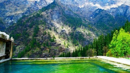
Kheerganga is a pilgrimage site linked to Lord Shiva and his son Kartikeya, and there is a small temple near the spring. The Parvati Kund hot-water pool has separate areas for men and women. Bathing is a highlight after the climb, but treat it as a sacred site: no soap or shampoo in the pool, and respect the temple area.
Best time to go
- March–June: pleasant days, green forest, the busiest season.
- July–August: the monsoon makes the trail muddy and slippery, and landslides can affect the roads. Best avoided unless you are experienced.
- September–November: clear skies, cooler weather, fewer people. Arguably the best time.
- December–February: snow on the upper trail. Only attempt it with a local guide and proper winter gear.
Cost and booking
You don’t need to book a tour to do Kheerganga. The trail is clear and well used, and many people go independently. Tour operators sell packages from Delhi that bundle the bus, a guide and a stay. These are convenient if it’s your first Himalayan trek, but check that any package’s itinerary reflects the camping ban. Village homestays are generally modest in price, and food on the trail costs more the higher you go.
What to pack
- Proper trekking shoes with grip. The upper trail is rocky and can be muddy.
- Layers: a warm fleece or down jacket even in summer, plus a rain jacket.
- At least 2 litres of water, or a filter bottle to refill at streams.
- Snacks, a torch or headlamp, sunscreen and a basic first-aid kit.
- A swimsuit and towel for the hot spring.
- Cash. ATMs are in Kasol and Manikaran, not on the trail.
- A bag to carry your rubbish back down.
Safety tips
- Don’t start the climb late in the day. Mist can roll in quickly and the forest gets dark early.
- Stick to the main trail, especially on the descent, and don’t trek alone.
- Altitude problems are uncommon at under 3,000 m. Still, go slowly and drink water, and come down if you get a bad headache or feel unwell.
- Mobile signal is patchy above Nakthan, so tell someone your plan.
Frequently asked questions
How long is the Kheerganga trek?
Can you camp at Kheerganga?
Is the Kheerganga trek difficult?
What is the best time for the Kheerganga trek?
How do I reach Barshaini from Kasol?
Sources & references
- Camping prohibited in Kullu's Kheerganga area — The Tribune
- Kheerganga trek: distance, route and best time — TravelTriangle
- Kheerganga camping ban: a trekker's guide — Whistling Hound
Written by
Ghulam Mustafa, Founder
BloggerEditor in Chief
Ghulam Mustafa is the founder and editor of Life in Lines. He has spent more than eight years writing and editing practical guides, and runs a UAE-based digital marketing agency specialising in SEO, AEO and GEO. He reviews the site’s health articles for accuracy and…
Every article is written by a named author, checked against primary sources and updated when the facts change.